


 03:20 AM
 nikhil

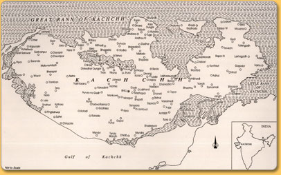
Kutch (also referred to as Kachchh) is a mystery land, not easy to comprehend. Kachchh is a sanskrit word meaning (land) which gets intermittenly wet and dry. Its vast length and breadth cannot easily be covered, and it is greater in area than some states of India. It’s the second largest district of the country (next only to Ladakh) located on the north-west frontiers of India.
Spread over an area of 45,652 sq. km., Kutch occupies almost one-fourth (24%) of the geographical area of Gujarat State. Besides, it accounts for nearly 60 percent of the drought-prone area of the State. More than half (i.e. 23,310 sq. km. or 51%) of its area consists of saline marsh of the Great and Little Ranns of Kutch which bound the district on the north and east.
It has a vast coastline of 352 kilometers with Arabian Sea that binds the district on the south-west.
It receives a low average annual rainfall of 380 mm during the south-west monsoon with an average of 15 rainy days in a year. Sometimes it gets intense rainfall within 24 hours which is more than the annual average.
Droughts are frequent – almost 6 in a cycle of 10 years. The temperature reaches up to 40 and often touch 50 degrees Celsius during the summer (April-June), while dropping to as low as below 1 degree during winter (January) in the interior parts of the district.
it is also strategically important from defense and security point of view.
0 ટિપ્પણી(ઓ):
ટિપ્પણી પોસ્ટ કરો